

The Hainan Meteorological Bureau has issued a Level III typhoon warning as Super Typhoon Ragasa, the 18th typhoon of 2025, moves closer to southern China.
At 8:00 am on September 23, Ragasa was located over the northern South China Sea, about 690 km southeast of Yangjiang, Guangdong. Winds near the center reached Force 17 (58 m/s, 210 km/h), making it one of the strongest storms of the season.
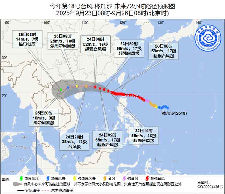
Ragasa is tracking west-northwest at 20–25 km/h and is forecast to make landfall on September 24 along the Guangdong coast between Shenzhen and Zhanjiang as a Severe or Super Typhoon (Force 14–16, 45–52 m/s). It will then move across the Leizhou Peninsula, gradually weakening as it continues westward.
Expected Impact on Hainan
September 23–25: Winds over the northern South China Sea will reach Force 14–17.
Around Hainan: From September 24–25, winds on surrounding waters and the Gulf of Tonkin are expected to increase to Force 11–12, with gusts up to Force 14.
Rainfall: Heavy to torrential rain is forecast for Hainan’s northern and western regions, with localized extreme rainfall. Other areas will see moderate to heavy rain.
Authorities advise:
Monitor updates from the Meteorological Bureau.
Prepare early for Qiongzhou Strait ferry disruptions.
Fishing boats should return to port, and northern Hainan ports should reinforce facilities.
Wider Regional Impact
Although Ragasa did not make direct landfall in the Philippines, its outer bands brought gusts over 315 km/h (195 mph), rainfall exceeding 400 mm (15 inches) in some areas, and triggered evacuations of more than 10,000 people in northern Luzon. Coastal areas of the Philippines’ Batanes and Babuyan Islands, eastern Taiwan, and later southern China and Vietnam face waves over 3 meters (10 feet) and flooding risks.
Related article: Essential Contacts details for Emergency services in Haikou