

As Typhoon Saola, categorized as a super typhoon, advances toward Guangdong’s eastern coast, local authorities are actively preparing for the potential impacts of the approaching storm.
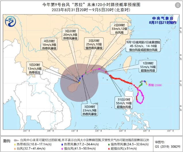
Meteorological monitoring places the centre of Typhoon Saola at coordinates 21.5 degrees north latitude and 117.3 degrees east longitude as of 8:00 PM on the 31st. This positions the typhoon approximately 245 kilometres southeast of Shanwei City in Guangdong Province, within the northeastern expanse of the South China Sea.
Authorities note that Typhoon Saola is currently exhibiting maximum winds reaching 16 on the Beaufort scale, equating to 55 meters per second. The anticipated trajectory indicates that the typhoon will move at an approximate speed of 10 kilometres per hour, veering in a west-northwest direction.
Landfall is projected to occur on the afternoon to evening of September 1st along the eastern coast of Guangdong, with the potential for the typhoon to be classified as a strong typhoon or even a super typhoon upon arrival.
The impact radius of Typhoon Saola encompasses its peripheral circulation, causing varying degrees of weather disturbances. Over September 2nd and 3rd, substantial parts of Hainan Island are expected to experience showers and thunderstorms, with localized regions facing heavy to torrential rainfall.
The Qiongzhou Strait will see winds at Force 5 to 6, occasionally gusting to Force 7 to 9. Other sea areas in the forecast are likely to encounter winds at Force 5 to 6, potentially escalating to Force 7 to 9 during thunderstorms.
To mitigate potential risks, the Hainan Provincial Flood Control and Drought Relief Headquarters have initiated Level IV emergency response for offshore typhoon defence. Coastal cities, counties, and autonomous counties are urged to enhance consultation and judgment processes, while making necessary preparations to initiate emergency responses in a timely manner.
Related article: Navigating Hainan Island’s Rainfall Risks: Understanding Mudslides and Flash Floods