

China’s National Meteorological Center (NMC) has issued a blue-level typhoon alert as Tropical Storm Fengshen gains strength over the central South China Sea.
As of 5:00 a.m. this morning, Fengshen, the 24th named storm of the year, was located approximately 520 kilometers east of Yongxing Island, part of Hainan’s Sansha City in the Xisha Islands. The storm is currently packing maximum sustained winds of 23 m/s (Force 9), with gusts expected to reach higher speeds. Its central pressure stands at 990 hPa, and the storm’s gale-force wind field extends 220 to 280 kilometers from the center.
Forecast Track and Intensification
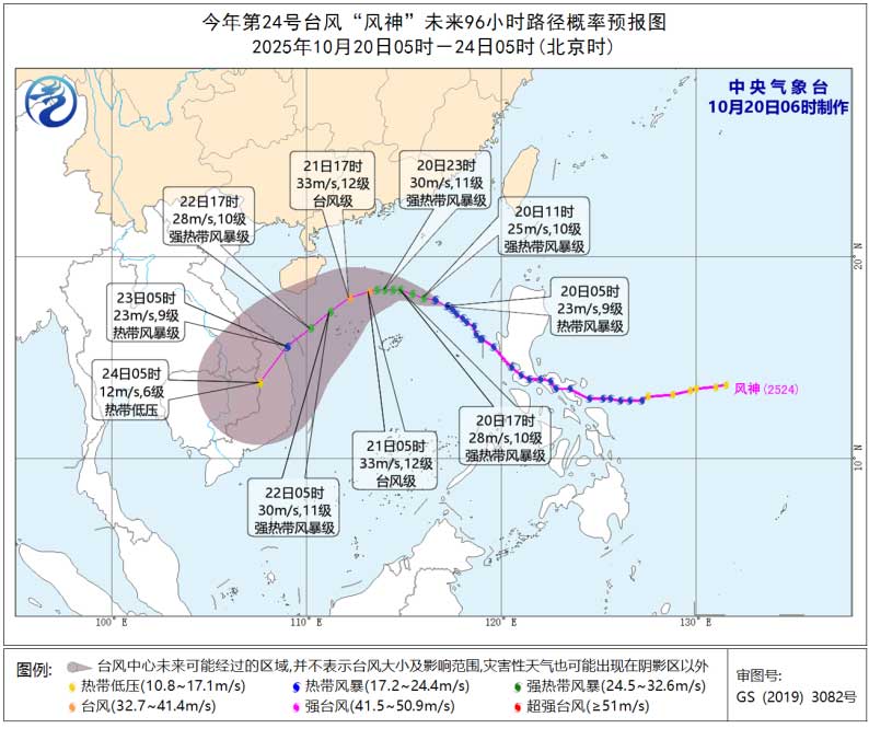
The typhoon is moving northwest at 20–25 km/h and is forecast to intensify over the next 24 hours. It could strengthen to a severe tropical storm or even reach typhoon status, with winds of 30–35 m/s (Force 11–12).
However, by October 21, a cold air mass descending from the north is expected to alter Fengshen’s path, pushing it southwest over the northern and central South China Sea. From there, the storm is projected to move toward central Vietnam’s coastline, gradually weakening as it approaches land.
Widespread Wind Impacts
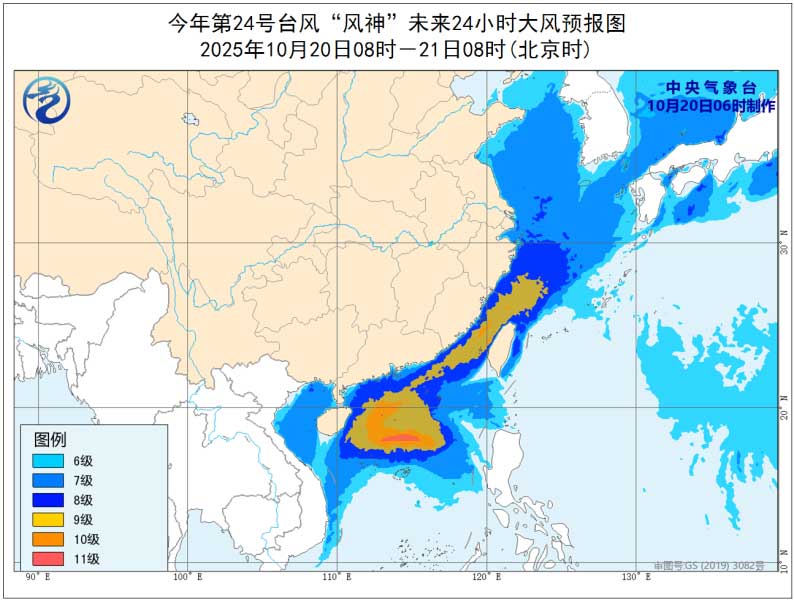
Between 8:00 a.m. on October 20 and 8:00 a.m. on October 21, strong winds are forecast across a wide swath of East and Southeast Asia’s maritime and coastal regions due to the combined effects of Fengshen and the incoming cold air.
Most areas can expect sustained winds of Force 6–8, with gusts reaching Force 9–10. In key zones, particularly the southwestern East China Sea, the Taiwan Strait, southern Zhejiang, Fujian’s coastline, eastern Guangdong, and parts of the northern South China Sea, winds may reach Force 9–11, with gusts peaking at Force 11–13.
The blue alert is the lowest of China’s four-tier typhoon warning system, but signals that hazardous conditions are developing and warrant close monitoring.
Related article: Help Us Get a Clearer Picture of Challenges Facing Expats in Hainan