

Typhoon No. 9 of this year, named “Saola,” initially classified as a Severe Typhoon, has further escalated its intensity and is now officially categorized as a Super Typhoon.
As of 06:00 AM on August 31st, the centre of the Typhoon was over the north-eastern South China Sea, situated approximately 320 kilometres southeast of Hui’an, Guangdong Province, with winds clocking in at 58 meters per second.
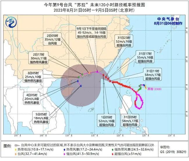
Its movement is expected to edge it progressively closer to the eastern coast of Guangdong Province. While its strength is predicted to wane gradually as it nears landfall, (anticipated to occur between the afternoon and evening of September 1st) the impact zone is expected to span from Huilai, Guangdong, to Hong Kong.
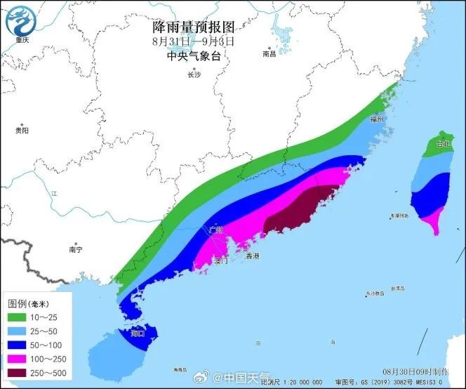
Between August 31st, 08:00, and September 1st, 08:00, substantial precipitation is predicted. The south-eastern part of Fujian, eastern Guangdong, as well as central and southern areas of Taiwan are poised to receive heavy to torrential rain, with some localized zones possibly encountering heavy torrential rainfall ranging from 100 to 220 millimetres.
It’s expected that the typhoon’s ferocity at this juncture will qualify it as either a Severe Typhoon or even a Super Typhoon, with wind speeds raging between 45 and 52 meters per second, equivalent to Level 14 to 16 on the Beaufort scale.
Previously:
August 30th, 2023 – In a weather development of concern, Typhoon Saola is currently tracking toward the South China Sea, raising the possibility of an imminent landfall. The tropical cyclone is also expected to bring heavy rain to Hainan Province.
Earlier reports indicated that Typhoon No. 10, named “Dawei” has dissipated, while Typhoon Saola continues its trajectory, gaining strength. With maximum wind speeds of up to 52 meters per second and a minimum pressure of 935 hectopascals, the storm’s seventh-level wind circle spans 220-250 kilometres.
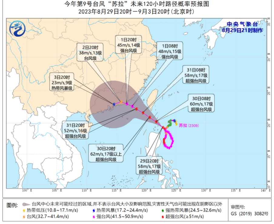
Current forecasts suggest that Typhoon Saola, currently at super typhoon level, will move north-westward at a speed of 10-15 kilometres per hour. Expected to enter the northeastern South China Sea by August 31st, the storm is projected to gradually approach the coastal regions spanning from southern Fujian to eastern Guangdong. A potential landfall is predicted between the night of September 1st and the morning of September 2nd along this coastal stretch, with wind speeds ranging from typhoon to strong typhoon levels (38-45 meters per second, equivalent to 13-14 on the Beaufort scale).
Typhoon Saola’s path uncertain

The storm’s path however, remains uncertain due to complex environmental factors. Meteorological analysts point out that the proximity of another developing storm, Typhoon Haikui, might result in a dual-typhoon interaction, affecting Saola’s course.
Typhoon Haikui, currently east of Typhoon Saola, is slowly strengthening as it moves in a north-westerly direction. Experts suggest that the interaction between these two storms could lead to unpredictable path shifts.
As Typhoon Saola’s impact unfolds, authorities advise residents to remain vigilant, as the situation could result in urban flooding, geological hazards, and potential flooding from small and medium-sized rivers.
In light of the rapidly changing weather conditions, the Central Meteorological Observatory issued a blue typhoon warning at 6:00 PM on August 29th, urging residents and relevant departments to take necessary precautions. Residents in Hainan Island should be prepared for heavy to torrential rain with some areas expecting localized accumulations exceeding 60 millimetres and alerts issued for the potential risks of flash floods and secondary hazards.
Related article: Navigating Hainan Island’s Rainfall Risks: Understanding Mudslides and Flash Floods