According to a weather report from the central meteorological observatory on September 8 at 17:00, the 13th typhoon of this year has been formed and is passing through the Philippines. Typhoon “Conson” has a projected path towards Hainan Island and is expected to interact with typhoon No.14 “Sandu” along the way.
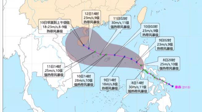
It is expected that typhoon Conson will move to the northwest at a speed of about 18 kilometers per hour and its intensity will gradually weaken. It will pass through the central part of Luzon Island in the Philippines and enter the South China Sea during September 9.
From then it will gradually move towards the western part of Guangdong, China, and the eastern part of Hainan.
As Conson approaches Hainan it is expected to interact with the 14th Typhoon Sandu. The second typhoon Sandu, is not on a path to Hainan Island but it will cause a double typhoon effect with Conson.
The dual typhoon effect of typhoon Conson and typhoon Sandu, also known as the Fujiwhara effect, refers to the interaction of two typhoons that are within close proximity. The effect occurs when two typhoons rotate around each other, which affects the typhoon’s form, intensity development, and path.
Due to the double typhoon effect, there is uncertainty about the specific movement paths of the two typhoons. The water vapor and power conditions of Sandu are relatively favourable, and the strength of Conson may weaken and its path may be adjusted slightly to the south.
Latest on Conson
As of this morning, Conson has passed through the Philippines and has entered the South China Sea. Click on the link below to track the typhoon in real-time.
According to data on the typhoon tracker, it is expected to reach the southwestern corner of Hainan by September 13.
Live typhoon tracker click HERE

Related article: Two baby Gibbons join the troop! Hainan Gibbon numbers on Hainan Island reach 35